Temel Bilgiler
Nakliye Yöntemi:Kargo, Hava Taşımacılığı, Kara Taşımacılığı, Deniz Taşımacılığı
Ürün Açıklaması
Ana Özellikler
 |  |  |  |
Veri Entegrasyonu | Özelleştirilebilir Alarmlar | Gelişmiş Yönetim | Erişilebilirlik |
DEM, CBS, uydu görüntüleri, GNSS, GeoSAR ve sensörler dahil olmak üzere çok kaynaklı veriler. | SMS, e-posta ve doğrudan uyarılarla dört seviyeli alarm sistemi. | Uzak izleme sistemi erişimi, kontrolü ve dinamik deformasyon görselleştirmesi. | Yerel ağlar, İnternet, mobil uygulamalar ve H5 arayüzleri aracılığıyla erişilebilir. |
Ürün Açıklaması
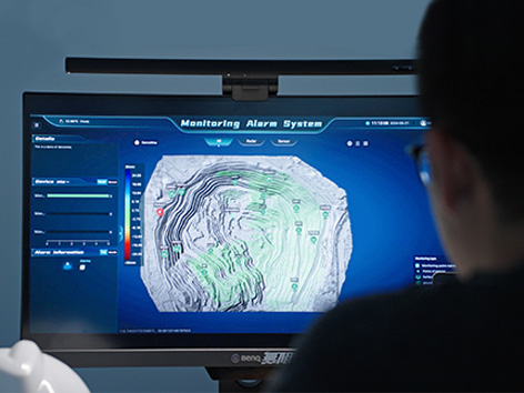
CHCNAV MAS, gerçek zamanlı izleme, veri görselleştirme ve alarm yönetimi için tasarlanmış otomatik bir platformdur. Nesnelerin İnterneti (IoT), büyük veri ve gelişmiş 3D görselleştirme teknolojilerini entegre ederek MAS, kullanıcıların uzaktan izleme cihazlarından gelen verileri verimli bir şekilde yönetmelerini ve analiz etmelerini sağlar. Platform, altyapı izleme, çevre yönetimi ve risk değerlendirmesi dahil olmak üzere geniş bir uygulama yelpazesini destekleyerek kritik gerçek zamanlı içgörüler sunar ve karar verme yeteneklerini geliştirir.
Kullanım Senaryoları
 |  |  |
Maden Operasyonu İzleme | Heyelan Erken Uyarı Sistemleri | Baraj ve Rezervuar İzleme |
Faydalar ve Performanslar
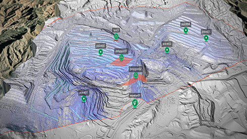
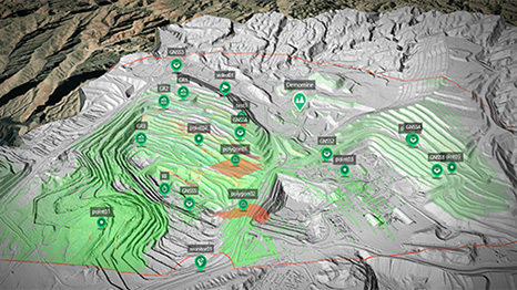
- Birleşik Veri Görselleştirme
MAS, DEM, CBS haritaları, uydu görüntüleri, GeoSAR ve 3D eğik fotoğrafçılık gibi birden çok kaynaktan gelen verileri tek bir ekrana entegre ederek kullanıcıların karmaşık veri kümelerini gerçek zamanlı olarak sezgisel bir şekilde analiz etmelerini sağlar.
- Gelişmiş İzleme ve Alarm Yönetimi
Platform, kritik bilgilerin ilgili paydaşlara zamanında iletilmesini sağlamak için SMS, e-posta veya doğrudan uyarılar aracılığıyla bildirimler gönderebilen özelleştirilebilir dört katmanlı bir uyarı sistemi sunar.
- Verimli Veri Yönetimi
MAS, GeoSAR, GNSS alıcıları ve çevresel sensörler dahil olmak üzere birden çok izleme cihazından gelen büyük veri kümelerini destekler. Platform, tahmine dayalı bakım ve risk yönetimini iyileştirmek için korelasyonların ve eğilimlerin görselleştirilmesini sağlar. - Platformlar Arası Esnek Erişim
Yerel ağlar, İnternet, mobil uygulamalar ve H5 arayüzleri desteğiyle MAS, kullanıcılara operasyonlarını dünyanın herhangi bir yerinden izleme, kontrol etme ve analiz etme esnekliği sunar. - Kapsamlı Sistem Entegrasyonu
MAS, uzaktan cihaz erişimi, parametre ayarı, kontrol ve alan deformasyonunu görsel olarak izlemek için deformasyon sonuçlarının dinamik gösterimi dahil olmak üzere kapsamlı GeoSAR yönetim hizmetleri sunar. - Gerçek Zamanlı Veri İzleme
MAS, veri ve ekipman durumunu sürekli olarak izler, anormallik durumunda anında uyarılar sağlayarak potansiyel sorunların zamanında tespit edilmesini ve ele alınmasını sağlar.