CHCNAV monitoring interface displaying a 3D terrain map with green-highlighted areas and data points.
Monitoring system screen displaying geological data with person analyzing the information.
Laptop displaying a login screen for CHCNAV monitoring system with scenic landscape images.
Laptop displaying a data analytics dashboard with colorful graphs and charts.
3D terrain map with labeled points, polygons, and contours, outlining a mining site layout.
Topographic map with marked locations, color-coded regions, and terrain elevation details.
CHCNAV monitoring system interface displaying mapped terrain with sensor data and alerts.
CHCNAV MAS 雲端監控與告警平台
物流方式:
快遞, 空運, 陸運, 海運
產品細節
附件
常問問題
基本信息
物流方式:快遞, 空運, 陸運, 海運
商品介紹
主要功能
 

數據整合

可自訂告警
進階管理
可存取性
多來源數據,包含DEM、GIS、衛星影像、GNSS、GeoSAR及感測器。
四級警報系統,提供SMS、電子郵件和直接警報。
遠端監控系統存取、控制及動態變形視覺化。
可透過區域網路、網際網路、行動應用程式及H5介面存取。

產品說明   

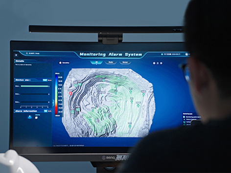
CHCNAV MAS 是一個自動化平台,專為即時監控、資料視覺化和警報管理而設計。透過整合物聯網 (IoT)、大數據和先進的 3D 視覺化技術,MAS 使使用者能夠有效率地管理和分析來自遠端監控裝置的資料。該平台支援廣泛的應用,包括基礎設施監控、環境管理和風險評估,提供關鍵的即時洞察,並增強決策能力。


應用案例
 
礦業營運監控

山體滑坡預警系統

水壩與水庫監測


效益與效能
  • 統一數據視覺化
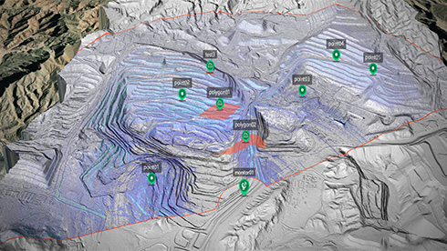
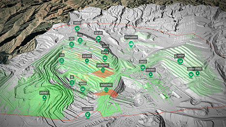
    MAS 將來自多個來源的資料,例如 DEM、GIS 地圖、衛星影像、GeoSAR 和 3D 斜攝影,整合到單一螢幕上,讓使用者能夠在即時直觀地分析複雜的資料集。

  • 進階監測與告警管理
    該平台提供可自訂的四級告警系統,可透過SMS、電子郵件或直接告警傳送通知,確保及時將關鍵資訊傳達給相關利害關係人。

  • 高效數據管理
    MAS支援來自多個監控設備的大型資料集,包括GeoSAR、GNSS接收器和環境感測器。該平台能夠視覺化相關性和趨勢,以改善預測性維護和風險管理。

  • 跨平台彈性存取
    MAS支援區域網路、網際網路、行動應用程式和H5介面,讓使用者能夠彈性地從世界任何地方監控、控制和分析其營運。

  • 全面系統整合
    MAS提供全面的GeoSAR管理服務,包括遠端設備存取、參數設定、控制以及變形結果的動態顯示,以視覺化追蹤區域變形。

  • 即時資料監控
    MAS持續監測數據與設備狀態,在出現異常時提供即時告警,確保潛在問題能被及時識別與處理。


留下您的資訊,
我們將與您聯繫。
微信
WhatsApp