CHCNAV monitoring interface displaying a 3D terrain map with green-highlighted areas and data points.
Monitoring system screen displaying geological data with person analyzing the information.
Laptop displaying a login screen for CHCNAV monitoring system with scenic landscape images.
Laptop displaying a data analytics dashboard with colorful graphs and charts.
3D terrain map with labeled points, polygons, and contours, outlining a mining site layout.
Topographic map with marked locations, color-coded regions, and terrain elevation details.
CHCNAV monitoring system interface displaying mapped terrain with sensor data and alerts.
CHCNAV MAS 云端监控告警平台
物流方式:
快递, 空运, 陆运, 海运
产品细节
附件
常问问题
基本信息
物流方式:快递, 空运, 陆运, 海运
商品介绍
主要功能
 

数据集成

可定制告警
高级管理
可访问性
多源数据,包括DEM、GIS、卫星影像、GNSS、GeoSAR和传感器。
四级警报系统,支持短信、电子邮件和直接警报。
远程监控系统访问、控制和动态变形可视化。
可通过本地网络、互联网、移动应用和H5界面访问。

产品描述   

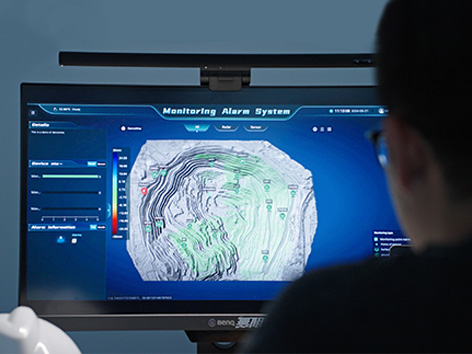
CHCNAV MAS 是一个自动化平台,专为实时监控、数据可视化和告警管理而设计。通过集成物联网、大数据和先进的3D可视化技术,MAS 使能用户高效地管理和分析来自远程监控设备的数据。该平台支持广泛的应用,包括基础设施监控、环境管理和风险评估,提供关键的实时洞察并增强决策能力。


应用场景
 
矿山运营监控

滑坡预警系统

大坝和水库监测


优势与性能
  • 统一数据可视化
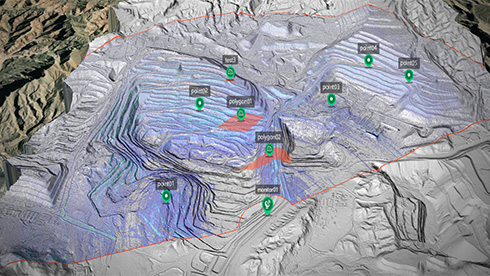
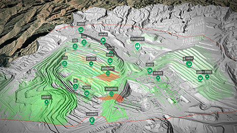
    MAS 将 DEM、GIS 地图、卫星影像、GeoSAR 和 3D 斜视图摄影等多个来源的数据集成到单个屏幕上,使用户能够实时直观地分析复杂数据集。

  • 高级监测与告警管理
    该平台拥有可定制的四级告警系统,可通过短信、电子邮件或直接告警发送通知,确保及时将关键信息传达给相关利益相关者。

  • 高效数据管理
    MAS支持来自多个监测设备的大型数据集,包括GeoSAR、GNSS接收器和环境传感器。该平台能够可视化相关性和趋势,以改进预测性维护和风险管理。

  • 跨平台灵活访问
    MAS支持本地网络、互联网、移动应用程序和H5接口,为用户提供了从世界任何地方监控、控制和分析其运营的灵活性。

  • 全面的系统集成
    MAS提供全面的GeoSAR管理服务,包括远程设备访问、参数设置、控制以及变形结果的动态显示,以直观地跟踪区域变形。

  • 实时数据监控
    MAS持续监测数据和设备状态,在出现异常时提供即时告警,确保潜在问题得到及时识别和处理。


留下您的信息,我们将与您联系。
微信
WhatsApp